The Department of Environment and Natural Resources (DENR) unveiled a comprehensive strategy to address the persistent flooding issues affecting Metro Manila.
In a press briefing on September 4, DENR Undersecretary Dr. Carlos Primo David called on local government units (LGUs) across Metro Manila to collaborate with the DENR in implementing robust flood mitigation measures.
The agency's strategy focuses on several key initiatives, including the expansion of green spaces, the use of permeable pavements, and the establishment of offline flood storage systems. “These combined efforts are essential to reducing flood levels and enhancing our water management practices,” Dr. David emphasized.
Ambitious Reforestation and Restoration Projects
As part of its flood mitigation efforts, the DENR has set a bold target to plant three million trees in the Upper Marikina River Basin Protected Landscape over the next four years. This extensive reforestation project will involve partnerships with the Department of Public Works and Highways (DPWH), non-governmental organizations, local government units, academic institutions, and the private sector.
In addition, the DENR is engaging with private sector partners to focus on reforesting the Marikina Watershed and rehabilitating the historic Wawa Dam, which has been decommissioned since 1968.
Analyzing Vegetation Loss and Urban Expansion
During the briefing, Dr. David also presented satellite images highlighting a significant decline in vegetation within the Marikina River Basin over the past decade. Their analysis from January 2014 to January 2024 indicates a sharp drop in vegetation cover, largely driven by increasing urbanization. To address this issue, he advocated for the conversion of moderate vegetation areas into dense forests and the restoration of rivers to their natural floodplains.
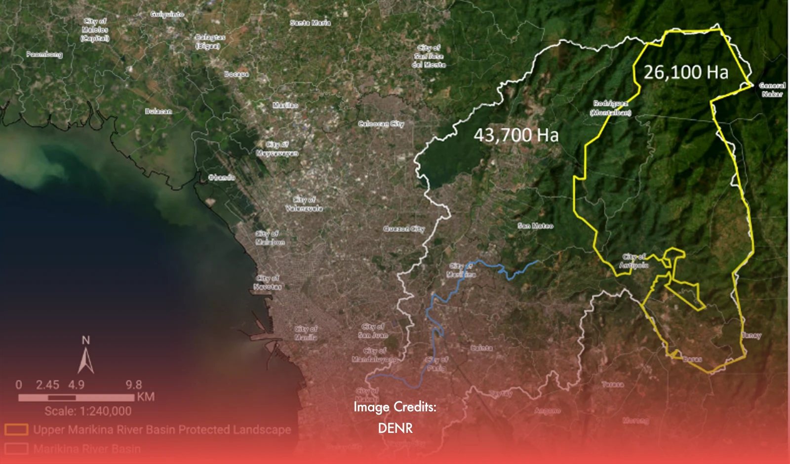
The Marikina River Basin, which spans parts of Metro Manila and Rizal province, includes the 26,123.6-hectare Upper Marikina River Basin Protected Landscape. The Marikina River itself flows approximately 11 kilometers, draining into the Pasig River after passing through several towns in Rizal and cities in Metro Manila.
In response to concerns about quarrying, Dr. David confirmed that no such activities have been detected within the Protected Area. “No quarrying was found in the protected area or the Upper Marikina River Basin Protected Landscape. The areas where there is a stark decrease in vegetation cover coincided with urban development.,” he clarified.
However, he acknowledged positive developments in forest cover in reforestation zones east of Antipolo and parts of Rodriguez.